

The Central Portuguese Camino de Santiago is the most established route and the second most popular Camino route after the French Way. But is it the right one for you? Hopefully, this article will help you make that decision.
As well as giving you information about the Central Portuguese Camino in general and addressing some common questions, such as “What is the terrain like?”, I’ll share my experiences of walking the 12 stages of the Central Portuguese Camino from Porto to Santiago in May 2016.
I’ve since relived this experience countless times through helping other people plan their own Camino and working closely with the tour operator to keep their roadbooks up to date as the Camino officials make small changes to the route. I spent a huge chunk of February 2023 working on Camino roadbooks so I’ve updated this article to keep it just as fresh and relevant.
You can skip ahead to my stage by stage accounts of the Camino Português or simply continue reading to get an overview of this route before digging into the details.
If you’re not sure what the Camino is, or have more general questions about it, read this page first.
What is there to see on the Central Portuguese Camino de Santiago?
If you’re starting in Porto, it’s well worth allowing at least a day to explore the UNESCO World Heritage city, which is famous for port wine. The historical centre is full of fascinating buildings full of stories and charm.
Among Porto’s highlights are the 12th century cathedral, which is naturally a stop on the Camino, one of the world’s most beautiful bookstores, amazing blue and white tiles and the colourful Ribeira neighbourhood beside the River Douro. Read more about what to do in Porto.
The further you get from the city of Porto, the more rural the landscape becomes and you’ll pass through a series of villages and peaceful countryside on the way to Barcelos. This small, ancient city is famous for the legend of the Barcelos cockerel which, with St. James’ intervention, miraculously saved a wrongly accused pilgrim from death by hanging. It is an attractive place with great architecture, ceramics and an open-air archaeological museum.
Once past the town of Barcelos, Portugal’s gorgeous Minho countryside opens up before you as you walk through forests, valleys and villages, not to mention a relatively challenging climb up a mountain just after the beautiful riverside town of Ponte de Lima.
The last town in Portugal is Valença, notable for its formidable fortress. Across the River Minho lies its counterpart in terms of medieval defence settlements. Tui’s battlements are part of its incredible cathedral – worth exploring before you leave town.
It’s possible to avoid the ugly industrial estate near O Porriño and stick to forest and riverside paths. Redondela is a small but pleasant town, significant because the Coastal Camino and Central Way become one here. After that, the riverside town of Arcade is renowned for its oysters and is a pleasant place to relax by the water, although it has little in terms of monuments.
The next city of note is Pontevedra with its vibrant historical centre and array of medieval squares in which to enjoy tapas of mussels or razor clams. Between Pontevedra and Santiago de Compostela you’ll pass through the spa town of Caldas de Reis where you can soak your weary feet in the thermal springs or just enjoy a glass of wine by the river.
Alternatively, you can follow the Variante Espiritual, which leaves the main trail shortly after Pontevedra for two beautifully scenic days followed by a boat trip that retraces the voyage made by the boat carrying St. James’ body from Jerusalem.
Padrón is not only famous for its small green peppers – try them if in season. It’s also reputedly where St. James’ body ended up after he was killed. You’ll see monuments to this effect around the small medieval town centre.
The highlight, of course, is Santiago de Compostela. The cathedral has grown from its humble beginnings as a chapel into a magnificent structure. The city that surrounds the cathedral is attractive, albeit touristy in the main streets leading to the cathedral. You can still find quieter spots and there is plenty to occupy you that merits staying an extra day or two once you’ve made it this far.
See this article for Things To Do In Santiago de Compostela
What’s the terrain like on the Central Camino Português?
As with any long distance walk, there is a mixture of tarmac roads, dirt tracks, stone paths and rather unforgiving granite cobblestones – make sure your footwear is well-cushioned and see my tips for packing for the Camino to see how else you can care for your feet on a multi-day hike.
It’s impossible to completely avoid busy roads but there are only a few places where this happens. Most of the time, you will be walking on country lanes or paths, interspersed with more urban surroundings.
There are more hills on the Central Portuguese Camino than on the Coastal route, notably Labruja mountain at 405 metres altitude. The other hills are not usually more than around 150-200 metres but can be taxing at the end of a long day.
When is the best time of year for the Central Way of St. James?
Winters in the north of Spain and Portugal can be quite cold and wet and it’s not uncommon for rural accommodations and some hotels to close for a while during the off-season. For that reason, I wouldn’t recommend doing the Camino between mid-November and February unless you can do it at short notice when you know the weather will be good. The tour operator I work with won’t be able to help you during this period though.
As this route is inland, you don’t need to worry about the wind as much as you would on the coast. Some sections can get waterlogged in winter months, requiring minor detours or, at the very least, waterproof footwear.
See my Camino packing tips for more on that subject.
How busy is the Camino Português?
Until you get to Redondela, where the Coastal Camino merges with the Central Way, there will be fewer people. After that, expect to see more pilgrims.
The most popular months for the Camino are May and September so it can be tricky to find accommodation on the fly. I would book well in advance as the tour operator I work with ends up having to turn away last minute clients because there are no available hotels, especially on certain dates that coincide with major local sporting or religious festivities.
If you are staying in albergues, you’ll find that there is a mad rush in the mornings to get a head start and nab a bed at the next hostel so if you are part of this crowd, you’ll meet plenty of people.
However, if you have the luxury of knowing that your next bed is booked and waiting for you, you can have a more leisurely start to the day and miss the herd. Dori and I found that although we walked in May, the bulk of these hostel pilgrims had already been and gone by the time we were on the road.
Central Camino Português Stages Map
As you can see from this map, the Central Portuguese Camino from Porto to Santiago is inland and almost directly northwards, encompassing many important towns and cities as well as small villages in northern Portugal and Galicia in Spain.
The overnight stops on this map are based around the location of hotels, rather than pilgrim hostels, so you can break your Camino up differently if you prefer. But this is the way I did it, as you’ll see below in my description of the stages.
Or alternatively,

Central Camino Português: Porto to Arcos (17 km / 10.5 miles)


Although I made a point of visiting Porto Cathedral while in the city, I didn’t actually start walking the Camino until the tour operator had dropped me off in the village of Mosterio, some 17 kilometres northeast of Porto.
I wasn’t being lazy, honest!
Trudging through the urban and industrial sprawl between Porto city centre and Mosteiro doesn’t get your Camino de Santiago off to the best start so skipping ahead is standard practice and makes the first walking day a manageable length.
From Mosteiro village square, I followed cobbled lanes and tarmac roads through village after village. Fortunately there was little traffic as pavements are also scarce.
The first particularly attractive village I encountered was Vairão with its leafy central square and picnic benches shaded by ancient oak trees. Ever curious, I took the short detour up the ramp to the chapel and was rewarded with views across to the coast.
Vilarinho is more of a small town, although the Camino doesn’t pass through its commercial area. I stopped for a hearty chicken lunch at Restaurante Castelo in the square before moving on, back into rural scenery through a small patch of forest.
The architectural highlights of this day’s walk are the two Roman bridges. The first one, Ponte D. Zameiro, or just plain old Ponte de Ave, is the most impressive. I joined the locals to peer over the sides and watch the ducks basking in the sun on their sand bank on the River Ave.
The other, Ponte de Arcos, lies at the entrance to the hamlet of Arcos where we spent the night. It’s a pretty spot, with a tree on the river bank that looked ideal for sitting under although I didn’t make it back there.
While in Arcos, I highly recommend spending some time hanging out among the locals in Café Barbosa.
Central Camino Português: Arcos to Barcelos (20 km / 12.5 miles)


A leisurely stroll along cobbled lanes, through farming lands and a patch of forest, took us from Arcos to Rates and the striking Romanesque church of local saint, São Pedro de Rates. While the historical centre of Rates looked attractive, we decided to push on rather than look around.
Important note: The Camino splits into two here so check the signs to make sure you don’t accidentally follow the Coastal Camino (Caminho da Costa).
More forests and country lanes, some of them a tad hair-raising thanks to the lack of pavements, brought us into the village of Pedra Furada.
The perforated stone that this village is named after comes with a legend. Apparently Saint Leocádia was buried alive and manage to escape her premature tomb by drilling a hole through the stone with her head!
The Pedra Furada café-restaurant is an almost obligatory stop for pilgrims. Its walls are covered in Camino paraphernalia and the bolinhos de bacalhau (fried cod cakes) are delicious.
Tip: We made the mistake of hoping to find a restaurant a few kilometres further on to have lunch but ended up having to walk all the way to the outskirts of Barcelos before we found a proper restaurant. I would plan to have lunch in Pedra Furada, where there are several restaurants, unless you’ve managed to rustle up a packed lunch.
After leaving the main road, the back roads led us through hamlets and villages that got grander the closer we got to Barcelos.
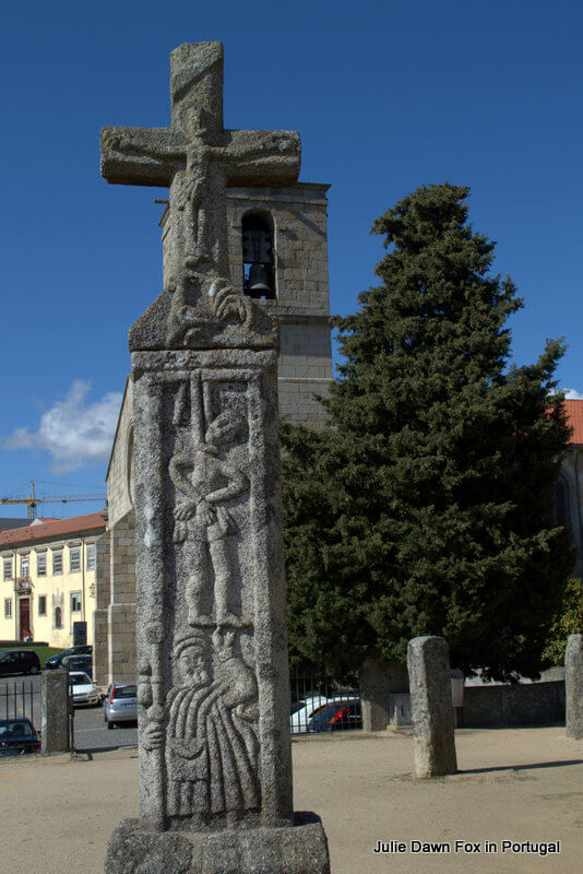
Another spectacular medieval bridge took us over the River Cávado, past the wonderful outdoor archaeological museum. Pop in if you have the energy to see the stone cross that depicts the legend of the Barcelos cockerel and how Saint James saved a wrongly-accused pilgrim from death by hanging. Pass the lovely Romanesque church and then you’re in the beautiful historical centre of Barcelos.
Tip: Treat yourself to a delicious cake from Confeitaria Colonial.
Once you’re refreshed, take a stroll around the charming historical centre of Barcelos, filled with surprising folk statues as well as interesting architecture. Here’s more about what there is to see and do in Barcelos.
Central Camino Português: Barcelos to Balugães (15 km / 9.3 miles)


When leaving Barcelos, the Camino Português takes you past the market square (which is usually in full swing on Thursday mornings) and through the outskirts of modern Barcelos into what I consider to be proper Minho countryside. In late April, this consists of fields of green speckled with yellow flowers, twisted grape vines just starting to sprout and patches of forest; mainly eucalyptus with some oaks thrown in.
We passed through the village green at Vila Boa and stopped for a coffee opposite the chapel of São Sebastião in Lugar de Ribeira. From here on, the steady climb towards the hilltop parish church in Tamel was green and pleasant. There’s a café/restaurant here as a welcome reward for your efforts.
The usual signs of small-scale agriculture were evident throughout in the form of grain stores, straw and haystacks, tiny fields full of dark green cabbages and the occasional sheep and goat. The most noticeable animals, however, were the frogs. It must have been mating season because these guys were making a racket!
Just before reaching Balugães, we crossed an ancient bridge near a teeny ‘river beach’ which I could easily imagine stopping at to bathe my feet on a hot day. It’s close enough to where you’ll probably be staying in the village that you could check in, dump your stuff and go back there to chill out later on.
Note: When Dori and I did the Camino, we spent the night in Quintiães but, if at all possible, I suggest you stick to the main Camino and stay in Balugães, which is a pretty village with a few eateries and a cute Romanesque chapel.
Central Camino de Santiago: Balugães to Ponte de Lima (18 km / 11 miles)


From the quiet village of Balugães, we passed through more verdant countryside and, after the village of Lugar do Corgo, began a fairly steep climb to Vitorino dos Piães. Do make a point of visiting the surprising collection of sarcophogi outside the modern church.
Tip: There is a café about 350 metres off the Camino in Vitorino dos Piães if you need refreshments but my advice is to bring a packed lunch or wait until you get to Seara (about 12 km into the stage) to stop for refreshments – there are a couple of bakeries here.
To make the continued climb a little easier, there is quite a bit of woodland between Vitorino dos Piães and the top of the hill. Once you start heading downhill again on a cobbled road after Quinta da Portela, the views of the Lima Valley and surrounding mountains are glorious.
We walked past colourful fields, apple orchards and, of course, grape vines supported by slabs of granite then a few outlying villages before entering Ponte de Lima alongside the river.
As one of my all-time favourite towns in Portugal, I was more than happy to reach Ponte de Lima. After a quick shower and rest, we waddled to Largo de Camões to enjoy a nice glass of vinho verde with some tremosos (lupin seeds). There are lots of restaurants here – if you fancy a decent steak or fish dish, try A Tulha.
Looking for a place to stay in Ponte de Lima? Search Booking.com
Central Portuguese Way of St. James: Ponte de Lima to Cossourado (22 km / 13.6 miles)


This is probably the most beautiful stage so far, although the views of the Lima Valley from yesterday are hard to beat. There is a small mountain to climb so take your time and enjoy the views.
If you have to leave the pretty town of Ponte de Lima behind, the most pleasant way to do so is by crossing the arched bridge across the River Lima. Fortunately, this is where the Camino de Santiago goes as it follows the ancient route used by the Romans between Bracara Augusta (Braga) and Austurica Augusta (Astorga).
On the other riverbank, there’s a Roman general summoning his troops on your left and an open Gothic chapel to your right.
Once over the bridge and past the Albergue, you’re almost immediately in the countryside again. I did this in May and the fields were brimming with flowers.
There are now more options for refreshments. The fish farm now has a self-service café that is aimed at pilgrims and supplies the makings for a picnic lunch to take with you if you didn’t bring what you need from Ponte de Lima.
Previously, the only option before climbing Labruja mountain was the café/shop in Revolta, about 9 kilometres from Ponte de Lima. There’s also another simple café a couple of kilometres down the hill so you don’t have to carry a picnic, although I would. The best picnic spot is at the top of Labruja Mountain, although there are no facilities here.

Climbing Labruja Mountain
Climbing the mountain is challenging but it’s not horrendous. It’s just a matter of taking your time, unlike the guy who almost jogged past us as we were sweating and panting our way slowly up the final steep gulley.
We heard his celebratory whoop after he’d disappeared from sight, which spurred me on, knowing the peak must be close.
By the time I reached it, he’d already taken his selfies and asked me to take one more picture of him before he sped off down the other side! I saw him later with his feet in a bowl of water at the pilgrim hostel in Rubiães where he’d been in a rush to nab a bed.
Everyone else we encountered considered this rocky area with its splendid views to be the perfect spot for a picnic and a well-earned rest.
The downhill stretch from Labruja is much easier, with views of distant mountains and several kilometres of woodland paths. At Rubiães, the Camino trail merges once again with the Via XIX Roman road, marked by an image of a chariot and rider.
The 12th century Romanesque church in Rubiães is worth the slight detour to see the stone carvings on the church and engraved Roman milestones in the churchyard. Some of them were later repurposed as sarcophagi!
Many pilgrims spend the night at the albergue in Rubiães but we had accommodation arranged in a country inn, another 4 km away in Coussorado. This meant crossing some more picturesque stone bridges and walking on quiet backroads to reach our peaceful haven.
If you’re looking for a fabulous B&B in the area, try Quinta Labruja. There you’ll find an exceptionally clean accommodation with very welcoming hosts. The bed and breakfast offers both vegetarian and gluten-free breakfast. Check out the rooms.
Pilgrim dinner
One of the highlights of the Camino Português for both Dori and I has been the camaraderie among the different people we met along the Camino. That evening, we had a communal meal with the fellow pilgrims who were staying at Casa da Capela.
Whether it was organised for convenience or conviviality, I don’t know but we all agreed to having dinner at 7 pm. That’s early for Portuguese standards but trust me, you’ll be going to bed earlier than usual if you’re doing the Camino so the quicker you get on with dinner, the better.
Around the table with us were two Dutch women we’d met the day before and two Brazilians. Wine and conversation flowed freely and the food was a million times better than the awful meal we’d had in Quintiães the night before. A night to remember!
For other options on where to stay in Cossourado, check out Booking.com
Portuguese Camino de Santiago: Cossourado to Valença (13 km / 8 miles)


Having walked uphill to reach our accommodation in Cossourado, we had very little climbing to do before we began the gentle descent into the Minho Valley the next morning.
The not-so-distant mountains of Galicia accompanied us as we walked through villages and agricultural lands until we joined the Via XIX once more. This leads through a pretty stretch of forest near the village of Cerdal where there is yet another medieval bridge.
This was the first day that Dori and I encountered LOTS of pilgrims. Those who stay in albergues tend to set off by 7 am in order to get first dibs on beds at the next one. Since we knew we had a comfy bed waiting for us at the end of each stage, we were in less of a hurry and usually on the road by 9 am, meaning that hostel pilgrims were already way ahead of us most days.
On this day, we were soon overtaken by the gaggle of walkers who’d started their day in Rubiães and were marching along at a fair old pace. The herd soon thinned out and they were long gone by the time we got to the muddy stretches of puddles that needed to be negotiated just before we got to the tarmac roads at Arão.
Although the Camino quickly leads away from the N13 road, the serenity of the countryside is over as you negotiate one more village before reaching the outskirts of Valença.
The town of Valença itself is reasonably attractive but its main draw is the fortress. If you’re using the same tour operator as I did to organise your accommodations, you will reach your hotel before hitting the fortress.
Note: The next stage of the Camino takes you through an impressive arched gate inside the walls, along a couple of shopping streets and past an ancient church before spitting you out through a narrow tunnel onto the avenue that leads to the bridge.
However, I suggest you use the afternoon to explore the ramparts and pretty squares inside Valença old town. See this article for more about what to do in Valença.
Tip: If you have the energy, and are interested in visiting Tui Cathedral, you might like to walk or take a cab across the river and enjoy the cathedral’s audio-guided tour at leisure today without waiting until tomorrow when you have the pressure of a full day’s walk ahead of you.
Dori and I had already visited Valença on previous occasions so we spent the night in Tui instead. Having arrived late afternoon, we were just able to manage a leisurely stroll in the park and around the main square before our aching backs forced us to crawl into our beds.
We also had our first taste of Galicia’s Albariño white wine. Although the Portuguese would probably argue that it is in some way inferior to their Alvarinho wines, we judged it to be perfectly drinkable. Especially with the complementary tapas.
Need help organising your Portuguese Camino?
If you like the sound of the ‘pampered pilgrim’ option with hotels, luggage transfers and the reassurance of an emergency contact, click the button below to get a quote for a customised itinerary.
Portuguese Camino de Santiago: Valença to O Porriño (20 km / 12.4 miles)


There’s a reason why Valença and Tui are popular starting points for the central Portuguese Camino de Santiago. If you want to qualify for a compostela, the official pilgrim certificate from Santiago de Compostela, you need to prove you have walked (or ridden a horse!) at least the last 100 kilometres. Both cities are within 120 km of Santiago making them good options if you haven’t got the time or physical stamina to do the earlier 5 stages from Porto.
To get to Tui from Valença you will walk through the fortress then cross the impressive road, foot and railway bridge over the River Minho. I loved the border crossing painted onto the footpath.
The International Bridge itself was inspired by Eiffel’s other feats of engineering and symbolises the peaceful relationship that now exists between these neighbouring countries.
Tip: Use the walkway on the right side of the bridge for the most tantalising views of Tui.
The sights of Tui and its fortified cathedral
While Valença built a fortress to protect itself from its enemies, Tui’s medieval stronghold was the cathedral itself. That explains the battlements on its towers and other architectural features that have more to do with military defence than religious devotion.
The Portuguese Camino leads you gently through the outskirts of the town and up through the medieval streets to the front of Tui Cathedral; a most impressive sight. We paid the small fee for the audio guided tour of the building and I for one enjoyed it. The views alone were worth the fee, not to mention the exquisite stone sculptures.
The rest of Tui’s historical centre is compact but atmospheric. You’ll walk through some of it simply by following the Camino but you’ll miss its hub unless you venture slightly off the Camino to Passeo da Corredera.
Tui to O Porriño
On the way out of Tui the next morning I noticed quirky details like snake door handles and tortured souls burning under a cross. These paled into insignificance compared to the magnificent stone cross outside the 11th century church of St. Bartholomew.
Once past yet another Roman bridge we had to endure a few kilometres of tarmac highways. I was getting mighty fed up and footsore by the time we finally turned off into the forest.
The greenery and less punishing surface soon cheered me up though. A small cross and shrine marks the spot where San Telmo, the Bishop of Tui, died of a fever on his return from a pilgrimage to Santiago de Compostela 750 years ago. It’s a beautiful place so we, like many pilgrims before and since, stopped for a rest by the stream.
Dori and I had done our homework before setting off, our primary concern being where to find cafés along the Camino. In doing so, we read about a couple of detours we could take to keep us amid greenery and, most importantly, avoid the industrial estate outside O Porriño.
Even so, we almost missed the turning!
Tip: When you see this mural in front of you, turn left into Orbenlle then take the first track on your left.
Thanks to this diversion, we spent the next few hours walking through woods and small villages before approaching O Porriño.

Update 2023: This is now a lot more clearly marked and widely accepted as the recommended route, although the next optional detour into O Porriño itself is not so well-signed. When you get to O Porriño, turn left after going under the motorway or right to walk along the main road on the official Camino route.
We picked left, following the river through more woodland right to the centre of town.
O Porriño hasn’t got much to look at, apart from the fancy Casa Consistorial in the main street. It does, however, have a range of cafés, restaurants and shops so we had no trouble getting food and drink.

Camino Português: O Porriño to Redondela (15 km / 9.3 miles)


Refreshed once more, Dori and I set off from O Porriño the next morning.
The first few kilometres beyond O Porriño were straightforward enough but it wasn’t until we approached Mos that the scenery became especially attractive. A row of low mountains came into view shortly before we reached Mos Palace and the church of Santa Eulália.
Tip: There’s a pretty square here with a couple of cafés; a good place to take a break before the next phase of the steady climb to an altitude of 235 m.
After passing through the village at the top of the hill and a patch of pine forest, the real challenge to our knees began.
The thrill at our initial glimpse of the Ria de Vigo estuary and iconic bridge was quickly eclipsed by the need to zig-zag our way downhill. If your walking shoes are tight around the toes, this is where you’ll feel it most!
To give our trembling legs a break, we ducked into a café and were delighted to discover their wisteria-covered beer garden, not to mention the rather tasty Estrella Galicia beer.
I’m glad we stopped as it gave us the energy we needed for the final stretch into Redondela, some of which is along the main road. Once we rounded the corner by the former convent, I was in familiar territory having previously walked to Redondela on the Coastal Camino.
Redondela, where two Camino routes become one
The Coastal Camino enters Redondela at a slightly different point from the Central Portuguese Camino but the routes soon merge on Rúa Pai Crespo and from here, there is only one Camino all the way to Santiago de Compostela, barring a few optional detours and alternative routes.
Note: If you have been following the Coastal Camino, you will probably stay overnight in Redondela then walk to Pontevedra the next day, thus combining the Redondela to Arcade section below with Stage 8.
If you have been following the Central Camino, you will most likely be continuing on to Arcade to end this stage so aim to have lunch in Redondela before the final leg.
Things to see in Redondela
Redondela is a pleasant enough town, with plenty of restaurants and shops should you need supplies of any kind. In terms of sights, one of the most significant buildings is the 16th century Casa da Torre, which is now the pilgrim hostel and an art gallery.
Somehow, we missed the ancient church of St. James, which lies just off the Camino. I suspect we were too focused on finding food at the time.
For a place to stay in Redondela, search Booking.com
Portuguese Way of Saint James: Redondela to Arcade (7 km / 4.3 miles)


If, like us, you are continuing on from Redondela to reach Arcade, there is another small hill between you and your hotel. Fortunately this involves some forest and views of the Ria de Vigo lagoon, especially on the way down.
The final stretch into Arcade was less fun – we were exhausted by that point and had to watch out for trucks thundering past us on the main road.
Tip: If you’re tired, and not averse to the idea of skipping a short section of the Camino, I would consider taking a cab from Redondela to Arcade to save your energy.
Camino Português: Arcade to Pontevedra (13 km / 8 miles)
If you arrived in Redondela on the Coastal Camino, you would most likely have spent the night there and so see my previous notes about getting from Redondela to Arcade. Otherwise, this stage from Arcade to Pontevedra is blessedly short and beautiful, especially if you take the detours that we used.
Bonus optional detour: Arcade river beach


Dori and I had been too tired to explore when we arrived in Arcade but the next morning, with a relatively short stage ahead of us, we decided to investigate the waterfront by making a slight detour from the Camino. We followed the N550 and then the signs for Porto-Praia.
I’m so glad we did and would thoroughly recommend you do so too, either on the day you arrive or before leaving Arcade, depending on your energy levels.
There’s a small park area and sandy beach with the calm water of the Ria de Vigo stretching out into the distance.
We were going to retrace our steps back to the Camino until two local ladies out for their morning stroll told us we could simply follow the waterline and reach the historical Ponte Sampaio that way. Instead of traipsing through dark narrow streets, we strolled past beautiful views and bobbing boats.
Verea Vella da Canicouva


One of my favourite parts of the Portuguese Camino de Santiago was this ancient stone road that took us gently uphill past small fields and into a forest. Parts of the track has seen so much use over the years that deep grooves have been worn into the stones.
After the hill and forest, the countryside opens up again with rows of grape vines and distant mountains.
Riverside detour to Pontevedra


Since we had plenty of time and a relatively short distance to cover that day, we decided to take the scenic option to reach the city of Pontevedra. The local postman stopped us outside the tiny chapel of Santa Marta and asked for our help explaining the optional detour to two Polish pilgrims who spoke limited Spanish.
All four of us duly followed his directions and found ourselves in a pretty patch of woodland, surrounded by birdsong and the gently gurgling stream that we followed all the way to the outskirts of Pontevedra. It added an extra kilometre or so to our journey but was far more soothing than following the main road into Pontevedra.
Tip: If you take this detour, you won’t encounter any cafés between Arcade and Pontevedra so bring supplies. If you are starting from Arcade, you should get to Pontevedra in time for lunch but if you are coming from Redondela, aim to take a refreshment stop in Arcade and bring a packed lunch.
Note: If the weather is or has been very wet, it’s best to stick to the original Camino becasue the detour can becme flooded or slippery.
What to see in Pontevedra city centre


We arrived in Pontevedra in time to dump our stuff at the hotel and make it to one of the squares in the historical centre in time for a late lunch – luckily the Spanish tend to eat later than the Portuguese.
Sated and refreshed, we enjoyed a wander through the streets soaking up the old world atmosphere and pausing to admire the various architectural treats, including the 14th century Gothic Convent of St. Francis, the ruins of Santo Domingo church and the 18th century Baroque Sanctuary of the Virxen de la Peregrina.
Pontevedra’s main appeal lies in its countless squares and collonaded streets, which contain cute shops and eateries.
We failed to find anywhere that would serve us Padrón peppers in the evening (not the season, apparently) but consoled ourselves with white Ribeiro wine, slices of empanada (vegetable and seafood pie) and Galician-style octopus.
Camino Portuguese: Pontevedra to Caldas de Reis (22 km / 13.6 miles)


As we left Pontevedra’s pedestrianised centre behind, eerily quiet on a Sunday morning, we found more evidence of Roman occupation with excavations showing traces of the original Ponte do Burgo bridge and a replica milestone.
The first particularly attractive part of this full-day Camino stage comes about 4 km after Pontevedra, once you enter the forest. When you emerge into more open countryside, the number of stone crosses will leave you in no doubt that this is an ancient pilgrim path.
We spent most of the day amid crops and small vineyards where the vines are trained up posts so tall that they create vine tunnels.
Despite the occasional stint on the main road, it’s mostly a pleasant walk with no significant towns or monuments, except perhaps for the stone cross and communal laundry tank in the village of Tivo.
By this point, Dori and I and our new-found Camino friends, Sue and Jan, were more interested in the lovely café at the albergue, the first we’d seen for many a kilometre. A chilled Estrella Galicia beer later and we were ready for the final 2 km to Caldas de Reis.
Caldas de Reis
The entrance to the spa town of Caldas de Reis is marked by a stone church shortly before the bridge across the River Umia.
The easiest place to experience the thermal waters is Burgas springs, a small public fountain where you can take off your shoes and socks and bathe your weary feet. We also saw some pilgrims sitting on the edge of the communal washing tank with their feet dangling in the water.
Although Dori and I didn’t try it, the Balneario Acuña in Caldas de Reis has a pool and treatments that are open to non-residents as well as hotel guests. I suggest you try to book any treatments in advance though.
There are a few restaurants here so you should have no trouble finding refreshments – try the local wine served in a ceramic bowl from O Muiño by the bridge.
For accommodation in Caldas de Reis, search Booking.com
Portuguese Camino de Santiago: Caldas de Reis to Padrón (19 km / 11.8 miles)


As the end of our epic journey drew ever closer and the numbers on the distance markers got smaller and smaller we felt buoyed up, not to mention proud of ourselves and a little amazed given the concerns we’d had about our bad backs.
The centre of Caldas de Reis is tiny so although the waymarkers seemed elusive, there’s only really one way to go. Once past the church of St. Thomas Becket we headed towards the medieval bridge over the River Bermaña, worth a pause to admire its attractive setting.
After leaving the town behind, we walked through the beautiful green countryside of the Bermaña valley with its meadows and woodland. It was so delightful we barely noticed the gentle climb.
Tip: When you get to the N550 at Carracedo (about 5 km from Caldas) stop at Café Esperon for their excellent tortilla.
Past the 18th century church of Santa Mariña de Carracedo it’s uphill once more and into the shade of the Valga woods. The first village after the forest is São Miguel de Valga, where pilgrim motifs abound.
A string of hamlets and peaceful rural paths later and we found ourselves in the less than lovely village of Infesta, home to the Romanesque church of San Xulián de Requeixo. I particularly liked the carved cross outside the church and the accompanying information board which explains the iconography.
We crossed another bridge of Roman origin then followed the River Sar until it took us into Padrón via the market square and tree-lined avenue.
Padrón and the legend of Saint James


Padrón is said to be the place where the boat bearing the body of Saint James the Greater from Jerusalem landed.
The stone to which the boat was tied, O Pedrón, gave the town its name and is still protected by the church of St. James that was built around it. The church was closed when we were there but if you get the chance to go inside, ask to see the stone when you visit.
Across the bridge you’ll find a sculpture depicting this event at Fuente do Carmen as well as other motifs around the medieval streets and café-filled squares of the historical centre.
Portuguese Camino: Padrón to Santiago de Compostela (24 km / 14.9 miles)


Having looked at the elevation profile for what was to be our final stage, read the descriptions in our roadbook and spoken to other pilgrims, I wasn’t particularly looking forward to the last 24 kilometres that separated us from Santiago de Compostela.
Happily, the route was nowhere near as steep or industrial as I had feared and we spent much of the day in green countryside.
The first few kilometres took us through traditional Galician hamlets where residents were ploughing and planting their potato fields by hand and tall grape vines trailed up posts.
The reward for climbing uphill from Faramello was an enormous tree with a bench beneath, opposite a 14th century stone cross, one of the oldest on the Portuguese Camino.
The pretty village of Parada dos Francos, a little further along, has a small picnic area among the oak trees in the site where St. Martin’s Fair has been held each November since the 16th century.
Note: If you need to split this stage over two days, there is limited accommodation here. Mention this when you fill in the enquiry form to get your personalised itinerary and quote.
My favourite stretch of woodland came shortly after this village and took the sting out of walking uphill.
Our first glimpse of Santiago de Compostela appeared across the valley as we left the suburb of Milladoiro. The last few kilometres from that point were undoubtedly the toughest but we obeyed the graffitied sign at Ponte Rio Sar that said “Don’t Stop Now!”
You also have a choice to make just after the bridge: stick to the original route and slog up a steep hill or bear right through the trees for a more gentle approach to the city. We went right on what is now the official route into the city.
Update: You will encounter an extra option when you see a pair of waymarkers pointing in opposite directions. The shortest route is to take the second left after this point to cross the motorway.
Arrival in Santiago de Compostela


Waymarkers all but disappeared as we entered the city so keep your eyes peeled. When we finally found the historical centre and Porta de Faxeiras, the traditional entry to the city from the Portuguese Camino, we knew we had almost made it.
Santiago Cathedral, despite being partly clad in scaffolding and blue netting at that time, is an architectural masterpiece (this has since been removed and the exterior is beautifully clean and bright). We didn’t go straight in, wanting to rest first and get cleaned up before entering. Instead, we admired it from the outside and posed for a couple of photos then headed for the nearest café for a celebratory beer.
As we watched as other weary walkers made their way into Obradoiro square, we spotted other pilgrims we’d met time and time again along the Camino. Being able to share the sense of achievement with more than just each other definitely added to the experience.
Santiago de Compostela Cathedral
Santiago Cathedral dates back to the 11th century and has evolved through a number of architectural styles, the most obvious and ostentatious being the fanciful Baroque façade of O Obradoiro.
The Entrance of Glory (Pórtico da Gloria) was out of bounds for renovation but these works are now complete. If it’s anything like the rival Pórtico da Glória in Ourense Cathedral, you will be impressed, I’m sure!

We were able to see the caged crypt where St. James’ remains are kept and joined the queue to see the Romanesque sculpture of him that presides over the main altar.
Pilgrim mass and the botafumeiro
I had heard about the gigantic botafumeiro incense burner that hangs in the nave of the transept and was originally used to mask the stench of medieval pilgrims. Sadly, unless you pay a substantial fee and arrange it in advance, it only swings on certain days and they didn’t coincide with our dates.
We made do with the midday pilgrim mass, although I confess I didn’t stay for all of it. You can have your name read out during this service if you send a request in advance.


Things to do in Santiago de Compostela
When we planned our Camino de Santiago, Dori and I knew we wanted to reward ourselves with a couple of extra days to recover and explore Santiago de Compostela at a leisurely pace.
I’m so glad we did – find out what else there is to do in Santiago de Compostela.
There is also a practical reason for extending your stay here beyond one night in popular periods. The Pilgrim’s Office, which is where you go to collect your compostela certificate, can’t always issue the certificates on the day you arrive so you might have to go back the next day to collect yours.
Find out more about the compostela and how to qualify.
Thinking of walking the Portuguese Camino de Santiago?
If so, read more about it here and start planning your own Camino.
Note: As I mentioned in the article I wrote about preparing to walk the Portuguese Camino, the biggest regret we had was not factoring in any rest days. Although you can, in theory, walk from Porto to Santiago de Compostela in two weeks, I’d add a few extra days in before, during and after so you can properly enjoy what northern Portugal and Galicia have to offer.
Or alternatively,
GOING ON A LONG HIKE?
Get your free copy of my handy packing checklist for multi-day walks, including the Camino de Santiago, in PDF format.
Know what's essential to have with you, and what's nice to have if you're not carrying all your gear every day.

Halo, you mentioned that on your first day from Porto,you had the tour operator drop you off at Mostiero. using google maps, there is a Mostiero about 15km in a straight line from Porto (west north west. and east from Porto there is Mostiero de leca do balio about 6km straight line North.
If you’re asking which one it is, I mean Mosteiró near the Vilar do Pinheiro metro station.